
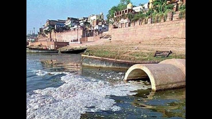
LUCKNOW: The Uttar Pradesh government is intensifying efforts to curb river pollution through a technology-driven approach aimed at achieving zero discharge into major rivers across the State.
The authorities have undertaken extensive drone surveys covering more than 400 kilometres along key river stretches, including the Ganga, Yamuna, Gomti, Varuna and Pandu, to identify pollution sources and strengthen river rejuvenation initiatives.
The surveys, conducted across major urban centres such as Lucknow, Prayagraj, Varanasi and Kanpur, have enabled officials to map drains, pinpoint discharge locations and assess the overall health of river systems with greater accuracy.
The findings are expected to form the basis of targeted interventions in several districts, including Kanpur, Varanasi, Prayagraj, Hardoi, Ballia, Meerut and Mirzapur.
“Drone surveys covering over 400 kilometers of the Ganga, Yamuna, Gomti, Varuna, and Pandu rivers have injected fresh momentum into rejuvenation efforts. Surveys conducted in major cities such as Lucknow, Prayagraj, Varanasi, and Kanpur have enabled precise assessment of river conditions, identification of pollution sources, and mapping of drain discharge points. Kanpur, Varanasi, Prayagraj, Hardoi, Ballia, Meerut, Mirzapur are among the districts set to benefit first from this initiative. Based on the drone survey findings, a comprehensive action plan is being prepared to ensure zero discharge into rivers. Once implemented, the rivers in the district are expected to achieve zero-discharge status,” Anurag Srivastava, Additional Chief Secretary, Namami Ganga and Rural Drinking Water Supply Department, Uttar Pradesh told a media house.
Officials said the initiative is part of a broader effort to integrate advanced geospatial technologies into river conservation and pollution management programmes under the Namami Gange mission. The State Mission for Clean Ganga has combined drone imagery with scientific mapping tools to generate detailed datasets that provide a clearer picture of pollution pathways and drain networks.
“High-resolution aerial surveys have been completed along the Ganga main stem in Uttar Pradesh, generating precise geospatial datasets that are being integrated into a live GIS-based Drain Dashboard with 2D and 3D visualisation capabilities. The dashboard enables basin-level pollution monitoring, identification of hotspots and prioritisation of drain remediation measures.
“It is the first of its kind initiative where LiDAR based scientific data has been coupled with visual data generated through drone surveys. We are doing timely field-level validation by District Ganga Committees, effective coordination and participation to ensure targeted interventions and strengthened drain-based pollution management. The initiative will particularly help in preparation of comprehensive and accurate DPRs with identification of primary, secondary and tertiary drains and pollution load which it is carrying, National Mission for Clean Ganga, the parent department is helping a lot,” said Joginder Singh, Project Director, State Mission for Clean Ganga and Special Secretary, Namami Ganga and Rural Water Supply Department.
The GIS-based dashboard developed through the exercise is expected to help authorities monitor pollution hotspots in real time, prioritise remediation measures and improve planning for future interventions.
Highlighting the wider benefits of the initiative, Singh said, “In line with this vision, the identification of drains and pollution control measures has become more efficient. A drone-based, integrated rejuvenation action plan will not only rejuvenate rivers but also simultaneously create opportunities for cleanliness, employment, and environmental protection in rural regions. The advent of digital imaging drone technology is revolutionizing the planning, execution, and monitoring of river restoration initiatives.
Initially utilized for military reconnaissance, contemporary drones are lightweight, digitally stabilized, and frequently enhanced with AI, rendering them effective instruments for environmental conservation. Revitalizing rivers also contributes to generating prospects for cleanliness, job creation, and environmental safeguarding in rural communities. Digital imaging drone technology is changing the landscape of how river restoration projects are conceived, implemented, and assessed. Once mainly employed for military surveillance, today’s drones are lightweight, equipped with digital stabilization, and often supported by AI, making them formidable assets for environmental protection.”
For any query, kindly contact indiahealthbuddy@gmail..com


